

Main Heading of Page (h1)
 This information has been archived for reference or research purposes.
Archived Content
Information identified as archived on the Web is for reference, research or recordkeeping purposes. It has not been altered or updated after the date of archiving. Web pages that are archived on the Web are not subject to the Government of Canada Web Standards. As per the Communications Policy of the Government of Canada, you can request alternate formats on the "Contact Us" page.
Valour (Vol. 11, No. 4)
Strategic Concerns and Future Operations
JUSTAS and Project Epsilon: Integrated Intelligence, Surveillance, and Reconnaissance of the Canadian Arctic
by Levon Bond
Captain Levon Bond is an air force intelligence officer serving as the Analysis, Correlation, and Fusion (ACF) chief in the Intelligence, Surveillance, and Reconnaissance Division (ISRD) of 1 Canadian Air Division’s Combined Air and Space Operations Centre. In 2009, he deployed to Qatar as a Canadian exchange officer in US Central Command’s ISRD in support of the International Security Assistance Force and Operation Iraqi Freedom. He had previously served in Kandahar, Afghanistan, at the National Command Elements Provincial Operation Centre. Bond holds a BA (Hons) in philosophy from the University of Winnipeg, an MA in War Studies from the Royal Military College of Canada, and is currently taking graduate courses in air warfare through the American Military University.
![]()
For more information on accessing this file, please visit our help page.
Introduction
Canadians have historically relied upon extreme cold and vast distances to defend its massive and sparsely populated Arctic territories. These two great bastions of northern defence will no longer be a reliable bulwark against potential aggressors, since many climate researchers anticipate that the Arctic could be ice-free through the summer months before the end of the next decade. 1
An accessible Arctic would be an attractive transit route that would substantially reduce cross-continental shipping distances, and hence, would drastically increase the number of ships operating in Canada’s Northwest Passage. Altered Arctic seaways will have important security and defence implications, as the disappearance of summer ice will leave the north coast of Canada vulnerable to criminal activity and to military incursions by rival Arctic states.2 In terms of sovereignty, Canada’s claim to its territorial possessions, its waterways, and its underwater resources are not universally recognized by the other Arctic states, necessitating a greater governmental presence in regions that are largely uninhabited.
The mandate to defend Canadian sovereignty in the Arctic has been identified as one of the primary missions of the Canadian Forces (CF) for the 21st Century. Therefore, the CF will need to orient itself to this task, while the government will need to allocate sufficient resources to the Department of National Defence (DND), so that the CF can accomplish this mission. One of the key components of this mission is improved Intelligence, Surveillance, and Reconnaissance (ISR) capabilities in the Arctic, since both surveillance and enforcement are required for other nations and actors to take Canada’s claims seriously. In order to satisfy part of this requirement, the Canadian government has committed to the development of a satellite-based surveillance program named Polar Epsilon, which uses the Canadian owned and operated RADARSAT-2 satellite constellation. Meanwhile, the CF’s unmanned aerial surveillance program - the Joint Unmanned Surveillance Target Acquisition System (JUSTAS) - has been put on hold while it waits for the government to commit to the procurement of either a high or medium altitude, long endurance (HALE or MALE), unmanned aerial system (UAS). The first stage in developing suitable and appropriate security in the far north will be to establish an adequate sensing capability through the integration of aerial and satellite- based ISR.
This article will examine how the Polar Epsilon program, in conjunction with other CF projects such as JUSTAS, can be developed to fulfill the first of the six core CF missions, while satisfying the security requirements of the government’s Northern Strategy. I will make a case for employing layered and integrated ISR, utilizing different sensor capabilities offered by different platforms, thereby expanding the JUSTAS program and merging it with Polar Epsilon. This will entail the acquisition of both HALE and MALE UASs, capable of operating remotely through the use of space-based satellite data-links. By doing so, the Canadian Government and its armed forces will be embracing the UAS revolution that is already on course to change the nature of ISR.
Arctic Surveillance and Project Epsilon
The Conservative government has made Arctic sovereignty one of its major government initiatives, but it has yet to flesh out a comprehensive ISR program for the Arctic. In the June 2008 Canada First Defence Strategy, the top priority set by the government for the CF is to provide security at home, which includes the Arctic. The document states:
[The] Canadian Forces must have the capacity to exercise control over and defend Canada’s sovereignty in the Arctic.… As activity in northern lands and waters accelerates, the military will play an increasingly vital role in demonstrating a visible Canadian presence in this potentially resource rich region, and in helping other government agencies such as the Coast Guard respond to any threats that may arise.3
Of the six core missions identified in this document, the first is to “… conduct daily domestic and continental operations, including in the Arctic and through NORAD.”4 The Canadian defence strategy was followed by “Canada’s Northern Strategy: Our North, Our Heritage, Our Future” in July 2009.5 In terms of ISR, the document only briefly mentions the Polar Epsilon project, with the RADARSAT-2 satellite to be used in a maritime surveillance role, but it does not commit to any other ISR programs. Considering the poor infrastructure, the sparse population, and the vast territorial expanse of the Canadian Arctic, the ISR systems required for sufficient coverage of the north will have to be both air- and space-based. Polar Epsilon constitutes a good beginning, but additional resources will be required to produce a robust ISR capability
Established on 30 May 2005, Polar Epsilon is designed to provide all-weather day/night surveillance capabilities utilizing imagery through the Canadian-based RADARSAT-2 satellite constellation. The program itself is estimated to cost $64.5 million,6 although the Government of Canada has invested $445 million to support the construction and launch of RADARSAT-2, which is owned and operated by MacDonald Dettwiler and Associates (MDA). The government support was necessary to keep the project in Canada, and, once completed, it will provide users a variety of satellite-based products and capabilities. The Canadian Space Agency (CSA) boasts: “Canada's next-generation commercial radar satellite offers powerful technical advancements that will enhance marine surveillance, ice monitoring, disaster management, environmental monitoring, resource management and mapping in Canada and around the world.”7 According to Doug Bancroft, the Director of Environment Canada’s Canadian Ice Service, “Routine surveillance to support sovereignty and security in the icy waters of the North would not be affordable without RADARSAT programs.”8 The program is comprised of three satellites, which are expected to be launched between 2014 and 2015.9 According to the RADARSAT-2 information page, “Each satellite has a capability to perform 12 minutes of active detection per orbit, for a total of 36 minutes... This 36-minute active detection [window] is long enough to capture images over Canada from coast-to-coast-to-coast… providing full coverage of the area every 10 hours.”10 Lieutenant-Commander Robert Quinn, the Polar Epsilon Project Director, also claims that the information can be formatted and made available in just 15 minutes, which will provide near-real-time intelligence for defence and security agencies.11
The real advantage of the Polar Epsilon program for an ISR role is its consistency. CSA maintains: “Earth-observation satellites have an advantage over aerial surveillance missions. Satellites operate day and night in all weather conditions, and provide timely coverage of vast areas.”12 During periods of increased Arctic traffic, images of fixed positions, such as ports and collecting points for naval vessels, can be collected twice daily, a capability that will be invaluable for tracking the movement of vessels of interest (VOI). “RADARSAT-2 improves ship detection with its Ultra-Fine beam mode (three-metre resolution) and offers the potential for ship classification.”13 Images of named areas of interest (NAI) can be taken on a routine basis, and then analyzed for accounting purposes. If a VOI is no longer observed at its last known location, the CF, in conjunction with the Canadian Coast Guard or the RCMP, will be alerted to the fact that the VOI is ‘on the move,’ and will need to be tracked, using a different surveillance method until the VOI is again spotted at a NAI. It will enable government agencies to determine who is where, and for roughly how long.
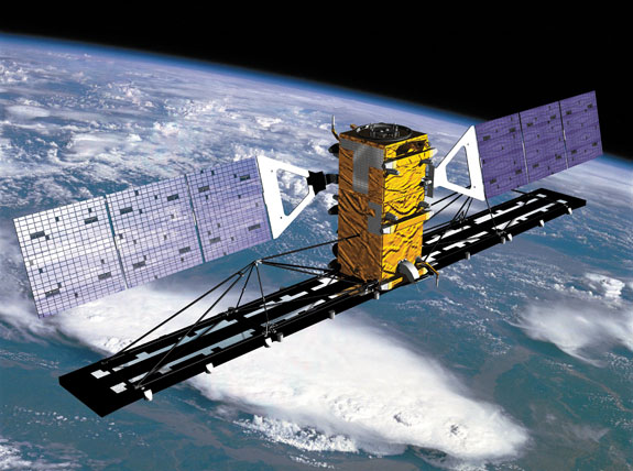
CSA image
RADARSAT
This program will be an instrumental step towards providing observation of Canada’s maritime domain, but it will have limited utility without integration with other ISR assets. In his description of the Polar Epsilon project, Major P.J. Butler of the Directorate of Space Development maintains that the RADARSAT-2 synthetic aperture radar (SAR) capabilities will need to be cued with other maritime surveillance assets in order to achieve near-real-time ship detection, and develop the recognized maritime picture (RMP).14 He states: “The overall requirement in domain awareness is to detect, classify, identify, track and determine intent. As no single sensor is capable of meeting all of these requirements all of the time, the strongest surveillance architecture exists when the strengths of all available surveillance sensors are used in a complementary manner.”15
For this reason, the system should not be used in isolation from other aerial surveillance platforms, and should not be the sole provider of intelligence imagery. This means that the tasking and processing components of the RADARSAT-2 imagery should be co-located with the like processes of other intelligence collection platforms, or at least remotely linked. RADARSAT-2 imagery can provide near-real-time intelligence, but only if the imagery is quickly analysed and disseminated to other principal agencies, so that they can either act upon the intelligence, or use the information to re-task other platforms to continue surveillance. This effort will need to be both interagency and joint in scope and involvement.
Canadian Forces UAS Requirements
With RADARSAT-2 firmly established in the Government of Canada’s plan for Arctic surveillance, the question remains as to what additional systems will be required to provide integrated ISR coverage in the north. The Canadian Air Force will be required to obtain and employ emerging aerial reconnaissance technology similar to what is presently utilized by the US Air Force (USAF), albeit on a much smaller scale. As the CF continues to rebuild its capabilities after the dearth of procurement in the 1990s, UAS technological innovations provide the ideal solution to the problem of Arctic surveillance, and could put the CF at the forefront of the robotics revolution in military operations. In his book, Wired for War, P.W. Singer argues that the robotics revolution is not a future possibility, but a present reality. For example, he claims that since the start of the war in Iraq, “… the Pentagon estimated that the demand for drones has gone up 300 percent each year.”16 Singer claims that there were 5331 drones of various sizes and capabilities in the US military inventory as of 2008, which was almost double the complement of manned aircraft.17According to Jane’s, the USAF currently operates 125 MQ-1 Predators,18 - 44 MQ-9 Reapers, and 17 RQ-4 Global Hawk UASs,19 with well over double the number of the latter two systems expected to be in service in the near term.20 These acquisitions are a part of a larger shift within the USAF towards unmanned air operations.
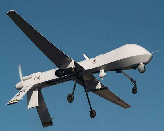
USAF photo 030813-F-8888W-006
MQ-1 Predator
The Canadian Air Force has been anticipating the changing nature of ISR operations, and in its strategic planning document entitled Projecting Power Trends Shaping Canada’s Air Force in the Year 2019, produced by the Canadian Forces Air Warfare Center (CFAWC), several trends involving Arctic surveillance and the use of UASs are identified. This document states, “The Arctic will place greater importance on unmanned platforms, persistent surveillance and sustainment,” and, “Semi-autonomous and intelligent systems will revolutionize the way the Air Force operates. The number of unmanned aerial vehicles within the Air Force will increase, and new concepts and doctrine will be required to address the advent of mixed air fleets.”21 CFAWC anticipates CF participation in the emerging field of unmanned systems, but when this will manifest itself is still uncertain, since the government has yet to commit to the acquisition of larger UASs, preferring to lease systems as an interim solution.
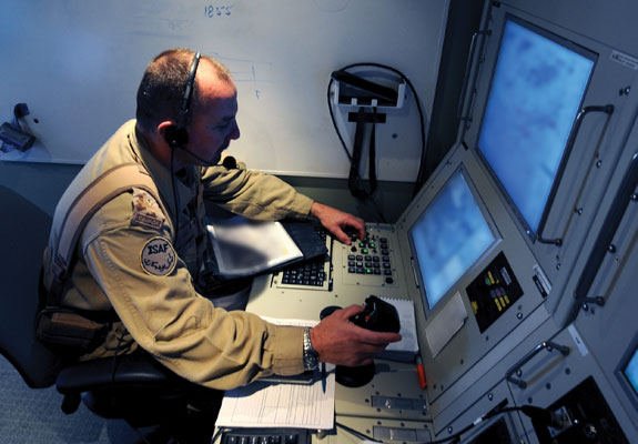
DND photo IS2009-0082(1)JP
Heron being operated from a Ground Control Station (GCS).
Although Canada was originally on the forefront of UAS development, the CF does not currently maintain a robust aerial ISR capability.22 Endorsed by the military’s Senior Review Board in October 2000, JUSTAS was originally conceived to provide a UAS capability for the Canadian Forces. The JUSTAS project is expected to proceed in two phases, with Phase One providing a domestic and expeditionary overland capability. Phase Two will involve the implementation of a domestic maritime and Arctic UAS capability.23 Prior to taking on its Arctic role, the HALE UAS were expected to operate out of the current CP-140 Aurora wings at 19 Wing in Comox, British Columbia, and 14 Wing in Greenwood, Nova Scotia, to provide coastal surveillance, while the CP-140s would deploy to Goose Bay, Newfoundland, for Arctic patrol missions.24
The timelines for the completion of these phases are uncertain, as it appears that the project has been delayed, due to both a lack of funding, and the current priority to maintain the tactical UAV (TUAV) capability in Afghanistan. Phase One appears to have been shifted to the Joint Airborne ISR Capability (JAIC) program, a temporary offshoot of the JUSTAS program. The CF has leased the CU-170 Heron TUAV since January 2009, which replaced the unreliable CU-161 Sperwer TUAV. The Heron has been able to provide the task force commanders with excellent electro-optical (EO)/infra-red (IR) full motion video (FMV) imagery that has been invaluable for mission planning and the maintenance of battle space situational awareness. The CF currently operates the Heron through a three year contract that will end in 2011, necessitating either a renewal or a transfer to another system. According to Major Andrew McCorquodale of the Directorate of Air Requirements, JUSTAS is expected to replace the Heron with a more robust all-weather air vehicle that will be capable of carrying weapons. It will be able to operate in icing conditions as well as in rain and snow.25
For the Phase Two HALE requirement, there really only exists one candidate, the Northrop Grumman Global Hawk RQ-4. The Global Hawk can accurately survey large geographic areas such as the Canadian Arctic, providing real-time information regarding the location, resources, and personnel of possible adversaries.26 The Block 10 Global Hawk has a range of up to 12,000 nautical miles at altitudes up to 65,000 feet, while flying at speeds approaching 340 knots for as long as 35 hours. However, following a typical mission profile, the aircraft can fly 1200 miles to an area of interest, and then remain on station for 24 hours.27 The US Navy (USN) procured two Block 10 Global Hawk Maritime Demonstration (GHMD) vehicles as a precursor to the Broad Area Maritime Surveillance (BAMS) development effort.28 The two Navy Global Hawks have participated in naval exercises such as Trident Warrior and RIMPAC, where they performed a wide range of maritime surveillance operations. The Global Hawk offers the greatest sensor range, and it relies upon SATCOM (satellite communication) data links, which could create a challenge when operating at high latitudes.29 Challenges notwithstanding, Dane Marlot, Manager of the International Business Development branch at Northrop Grumman, believes the Global Hawk is perfectly suited for coastal and Arctic surveillance, and he believes the corporation should compete for the JUSTAS contract.30 He claims: “We could cover an ID zone for the complete northern part of Canada in one mission rather easily. There are some issues with operating at northern latitudes, but we’ve operated in Alaska and at times have had to turn the aircraft to point toward the satellite, but that’s not a problem.”31
The one key ISR capability that neither the RADARSAT-2 nor the Global Hawk are able to provide is FMV, or persistent surveillance. Once a VOI has been identified via imagery, there will be a further requirement to maintain persistent surveillance on the vessel or individuals. This will require aerial FMV with a reasonably long ‘on station’ time. In Afghanistan and Iraq, Predator and Reaper UASs are employed to monitor insurgents preparing and planting improvised explosive devices (IED). Once a suspicious individual has been positively identified, UASs are able to maintain continuous surveillance by handing off the ‘overwatch’ between different airframes as they come on station. As Arctic traffic increases, it will become necessary to have such FMV capability to monitor vast regions that would be too distant for either foot or sea patrols to accommodate.
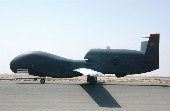
USAF photo 061003-F-7441T-003
RQ-4 Global Hawk
The General Atomics Predator B UAS is the ideal platform at this time for such a mission, with a capability of providing up to 20 hours on-station time. In March 2007, the CF proposed a sole-source purchase of the Predator B.32 Such a system could be used for Arctic surveillance, as well as in a theatre of operations supporting ground troops. Although the Government of Canada has acknowledged the value of such an acquisition, it has reneged in favour of a competitive tenure, which has yet to occur.
Command and Control of Arctic ISR
The primary command and control for any CF Arctic defence mission would naturally fall to Canada Command. On 29 June 2010, Polar Epsilon transferred its Arctic surveillance capabilities to Canada Command. Subsequently, Lieutenant-Commander Quinn announced: “We have delivered to Canada COM the ability to access RADARSAT-2 with exploitation software, and an image analyst who will help them exploit RADARSAT-2 from now on.”33 Canada Command is centrally located in Ottawa, and it works closely with other governmental organizations for the defence of Canada. Further, the Arctic sovereignty mission will be an all-of-government effort.
The ground stations for RADARSAT-2 will be located on Canada’s west coast in Aldergrove, British Columbia, and on the east coast in Masstown, Nova Scotia, thereby providing decentralized execution close to the Maritime Surveillance Operations Centres (MSOC) that exist on each coast.34 The intent with respect to Polar Epsilon is to have the satellite surveillance tied in with maritime surveillance, since maritime domain awareness is one of the primary missions of the RADARSAT-2 system. The JUSTAS program, however, is primarily an air force program, since it involves aircraft that will be managed and operated by the Canadian Air Force. As an ISR function, the JUSTAS program has moved to Winnipeg, where it can be combined with other ISR capabilities in the Combined Air and Space Operations Centre’s (CAOC) Intelligence Surveillance, and Reconnaissance Division (ISRD).
The CAOC in Winnipeg would be an ideal place for such a joint Arctic ISR effort. The Joint Forces Air Component Commander (JFACC) at 1 Canadian Air Division in Winnipeg is the Air Component Commander for the Commander Canada Command, and is responsible for providing air support for all Canada Command operations. Doctrinally, the ISRD of the CAOC is equipped with the personnel and resources to plan and task ISR missions; coordinate execution of these missions including dynamic re-tasking for ad hoc mission requirements; process raw intelligence; conduct various levels of analysis; and then disseminate the intelligence to the appropriate agency, all in a timely and efficient manner. Decentralizing the planning and processing of the Arctic ISR mission will reduce the overall integration of the ISR platforms and capabilities, thus creating too much lag time between the sensing and the execution of the mission. C2 necessarily will remain with Canada Command, but the planning, execution, and analysis of ISR missions should fall to the ISRD within the CAOC, while the military response to the finished intelligence products should then be tasked to appropriate elemental commands.
Conclusion
As the Arctic becomes a growing defence priority, and as the CF prepares to scale down its operations in Afghanistan, the period between 2011 and 2015 will be the optimal time for the CF to invest in the platforms, personnel, and support requirements of a more robust ISR capability that combines satellite and UAS systems. Although interim measures have been used to provide ISR for operations in Afghanistan, the JUSTAS program needs to become a procurement priority. The robotics revolution is upon us, and it is well on its way to changing the nature of air operations. Meanwhile, climate change is poised to dramatically alter the geo-strategic considerations in the Arctic. Without a substantial law enforcement and military presence therein, the use of HALE and MALE UASs will provide the most effective and efficient solution, enabling the CF to defend Canadian sovereignty, and to assist in the provision of domestic security in the northern frontier.
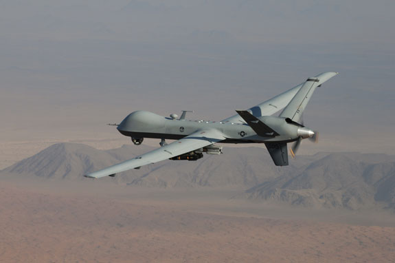
USAF photo 090127-F-7383P-00
MQ-9 Reaper
Notes
-
For example, University of Manitoba geoscientist David Barber, who was the head of the largest climate change study ever undertaken in Canada in the summer of 2007, estimates that by 2015, the Arctic will be ice-free in the summer. John Bowman, “Arctic ice melting faster than feared: study,” on CBC News, 5 February 2010. Also see Gwynne Dyer, Climate Wars (Mississauga, ON: Random House, 2008).
-
For a more detailed account of Arctic rivalries and what it means for Canadian sovereignty, see: Jennifer Parks, Canada’s Arctic Sovereignty: Resources, Climate and Conflict (Edmonton, AB: Canadian Currents, 2010); Ken Coates et al, Arctic Front: Defending Canada in the Far North (Toronto: Thomas Allen, 2008); Roger Howard, The Arctic Gold Rush (New York: Continuum, 2009); and Rob Huebert, “Canada and the Changing International Arctic: At the Crossroads of Cooperation and Conflict.” in IRPP, September 2008.
-
Canada First Defence Strategy, National Defence and the Canadian Forces, (2008), at http://www.forces.gc.ca/site/pri/first-premier/index-eng.asp?WT.svl=CFDLEFT. Accessed 12 December 2010.
-
Some of the government initiatives outlined in this document include the establishment of an Army Training Centre in Resolute Bay, the expansion and modernization of the Canadian Rangers, the establishment of a deep-water berthing and fuelling facility in Nanisivik, and the procurement of a new polar icebreaker in conjunction with the acquisition of new ice-capable patrol ships. Our North, Our Heritage, Our Future: Canada's Northern Strategy, Government of Canada, (2009), at http://www.northernstrategy.ca/index-eng.asp. Accessed 12 December 2010.
-
Polar Epsilon Project, National Defence and the Canadian Forces, 30 March 2009, at http://www.cefcom.forces.gc.ca/pa-ap/nr-sp/doc-eng.asp?id=2931. Accessed 12 December 2010.
-
RADARSAT-2, Canadian Space Agency, at www.asc-csa.gc.ca. Accessed 12 November 2010.
-
Serving Canada with RADARSAT 2, Canadian Space Agency, (2007), at http://www.asc-csa.gc.ca/pdf/radarsat2-serving-LR.pdf. Accessed 12 November 2010.
-
The RADARSAT Constellation: Status, Canadian Space Agency, at http://www.asc-csa.gc.ca/eng/satellites/radarsat/status.asp. Accessed 9 December 2010.
-
The RADARSAT Constellation: Program Description, Canadian Space Agency, at http://www.asc-csa.gc.ca/eng/satellites/radarsat/description.asp. Accessed 9 December 2010.
-
Kristina Davis, “Project Polar Epsilon: Canada’s security and surveillance enhancement,” in The Maple Leaf, Vol. 8, No. 26, 13 July 2005, at http://www.forces.gc.ca/site/commun/ml-fe/article-eng.asp?id=2824. Accessed 7 December 2010.
-
RADARSAT-2, Canadian Space Agency, at www.asc-csa.gc.ca, Accessed 12 November 2010.
-
Major P.J.Butler, “Project Polar Epsilon: Joint Space-Based Wide Area Surveillance and Support Capability,” in International Society for Photogrammetry and Remote Sensing, at http://www.isprs.org/publications/related/ISRSE/html/papers/1000.pdf.. Accessed 15 November 2010.
-
P.W. Singer, Wired for War (New York: Penguin, 2009), p. 217.
-
Each unit costs approximately US$ 4.5 million, which is remarkably cheap compared to the JSF F-35.
-
Global Hawks are a bit more expensive than the Predators, at a cost of US$ 35 million each.
-
Air force, United States, Jane's Sentinel Security Assessment - North America, 23 November 2010.
-
Lieutenant-Colonel Lachance et al, “Projecting Power Trends Shaping Canada’s Air Force in the Year 2019,” in Canadian Forces Aerospace Warfare Centre, 15 April 2009, at http://www.airforce.forces.gc.ca/CFAWC/eLibrary/pubs/Projecting_Power_2019.pdf.
-
Andrew Carryer, “A History of Unmanned Aviation in Canada,” at MacDonald, Dettwiler and Associates Ltd. (2008), at http://www.uavs.ca/outreach/HistoryUAVs.pdf.
-
Major Neil Scott, “A Vision for the Future of Maritime Aviation,” in Canadian Air Force Journal, Vol. 3, No. 3 (2010), pp. 21-26, at http://www.airforce.forces.gc.ca/CFAWC/eLibrary/Journal/Vol3-2010/Iss3-Summer/Sections/06-A_Vision_for_the_Future_of_Maritime_Aviation_e.pdf.
-
With the current pause with respect to JUSTAS, it is uncertain whether this approach will persist, or whether the HALE will be immediately tasked to Arctic patrols. CASR Background: CF UAVs, in Canadian American Strategic Review, at http://www.casr.ca/bg-uav-index.htm. Accessed 1 December 2010.
-
Major Andrew McCorquodale, Canadian Forces Briefing on UAVs, at Canadian Owners and Pilots Association, Flight 8, 24 June 2009, at http://web.ncf.ca/fn352/flight8/recent.html#UAV. Accessed 10 December 2010.
-
RQ-4 Global Hawk: Fact Sheet, Northrop Grumman, at http://www.as.northropgrumman.com/products/ghrq4b/assets/HALE_Factsheet.pdf. Accessed 10 December 2010.
-
Joetey Attariwala, “UVS Technology in Canada: Unmanned Systems offer solutions for many CF projects,” in Canadian Defence Review, October 2007, p.18.
-
Procurement, Canada, in Jane's Sentinel Security Assessment - North America, 18 October 2010.
-
Steve Fortin, “A new step for the Polar Epsilon project,”in The Maple Leaf , Vol. 13, No. 24, 21 July 2010, at http://www.forces.gc.ca/site/commun/ml-fe/article-eng.asp?id=6335.
-
David Pugliese, "Locations of Polar Epsilon Ground Stations Announced,” in the Ottawa Citizen, 30 March 2009, at http://communities.canada.com/ottawacitizen/blogs/defencewatch/archive/2009/03/30/locations-of-polar-epsilon-ground-stations-announced.aspx.