


Views and Opinions

Library and Archives Canada, Acc. No. R9266-2102 Peter Winkworth Collection of Canadiana
A view of the taking of Québec, 13 September 1759.
The Plains of Abraham, 1759: Where was the battle really fought?
by Earl John Chapman and R. Paul Goodman

For more information on accessing this file, please visit our help page.
Background
The battle on the Plains of Abraham, 13 September 1759, is arguably the most famous battle fought on Canadian soil. It still has major cultural and political reverberations exhibited by the ongoing debates over its legacy.1 One historian has expostulated that it took over five hundred years for the strong feelings of the Anglo Saxons with respect to the Norman Invasion of England to subside. Less examined, in recent and past publication, is the actual position of the British and French battle lines as they relate to the modern topography of Québec. Perhaps not surprisingly, the authors discovered that the placing of an historical plaque in Québec in 2009, commemorating the participation of the 78th Foot (Fraser’s Highlanders) in the battle, generated a controversy in the local Irish community. This brief article directs attention to where the battle was actually fought, since imprecise or erroneous depictions have been offered to historians, the interested public, and battlefield tourists over the last 180 years. Due to recent developments in computer geo-referencing, this imprecision can now be more accurately addressed.
As presented in the authors’ recent paper, “Québec, 1759: Reconstructing Wolfe’s Main Battle Line from Contemporary Evidence,”2 the surviving record of contemporary engineers’ maps of the battle (in repositories on both sides of the Atlantic) were studied and analyzed. The idea for a computer-generated map, as described herein, evolved from this study, and an attempt was initiated with a view to arriving at a higher degree of accuracy in pinpointing the location of the battle on the present topography of modern Québec. This is not a simple mapping proposition. Overlaying a historical map (even if drawn from actual survey by the best map making engineers at the time) with its modern topographic equivalent presents technical difficulties which will be discussed later. Fortunately, the authors were able to enlist the expert services of a geo-referencing specialist, Stéfano Biondo of the Centre GéoStat, Bibliothèque de l’Université Laval (Québec).3 His geo-referenced map uses one of the manuscript maps studied in our article referred to above. Before addressing the technical details of the geo-referencing process, and the conclusions which we can draw from Mr. Biondo’s map, a brief review of the previous attempts to locate the 1759 battle lines with respect to the modern streets of Québec is in order.

Stéfano Biondo, Centre GéoStat, Bibliothèque de l’Université Laval, 2015
Position of the two main battle lines produced by the georeferencing process between a contemporary battlefield map [LAC NMC 21345] and a current Québec City map with the modern streets.
Previous attempts to identify the site
There have been many early attempts to identify the precise site of the battle on the Plains of Abraham in 1759. In 1834, Alfred Hawkins determined that the battle was fought in the vicinity of the old race course, revising his findings in 1844 when he placed it a little to the east.4 In 1876, Sir James LeMoine jumped into the debate, placing the British line close to Avenue de Salaberry.5 Shortly afterwards, Francis Parkman placed the British line close to Avenue des érables (formerly Maple).6 In 1899, Arthur Doughty picked up the challenge, basing his conclusions primarily upon eyewitness accounts. His paper included a map (‘Plan A’), which was prepared in June 1899 by G.E. St. Michel, who was associated with the Québec Seminary (Séminaire de Québec). In this paper, Doughty criticized Hawkins, contending that the race course did not form any part of the battlefield, and stating specifically that the British line was formed roughly along Avenue de Salaberry, extending well north of Chemin Ste-Foy (the old St. Foy Road).7
A few years later, (c.1901), St. Michel revised his map, now placing the British line slightly west of Avenue Cartier (and extending to Chemin Ste-Foy). He was assisted in his new calculations by Elzear Clarest, Architect and Engineer of the Province of Québec, and Louis A. Vallée, Director of Railways of the Province of Québec.8
In 1901, with the assistance of G.W. Parmelee, Doughty refined his calculations but continued to disparage Hawkins and his “comparatively modern blunder” in choosing the race course as the field of battle, even though Hawkins had corrected his initial site. At this time, Doughty and Parmelee categorically stated that “… the British army was drawn up in battle array, facing the town, almost on the present line of de Salaberry street, and extending from near the heights overlooking the St. Lawrence, almost at right angles across the Grande Allée and St. John street…”9
A year or so later, not to be outdone, Philippe Baby Casgrain, a land surveyor and civil engineer in the Province of Québec, published a lengthy and rambling paper which criticized the work of Doughty and Parmelee. Casgrain’s argument is difficult to follow, but he appears to put the original British line closer to the race course: “… the English army was formed into line across the race course and extended from the ridge of the cliff to and beyond the Ste. Foye [sic] road; that the opening of the battle on the English side took place when and after they had advanced on the eminence of the jail, where they awaited the fire of the enemy…”10
In 1903, Doughty ‘took another kick at the can,’ publishing Québec Under Two Flags with fellow librarian N.E. Dionne, and writing: “Wolfe’s line of battle extended almost from the cliff near the river St. Lawrence to the St. Foy Road, in a line with de Salaberry Street; and Montcalm’s army met in a parallel line separated by only a distance of 40 yards.”11 This conclusion is essentially what Doughty and Parmalee wrote in 1901. Finally, in 1908, Doughty produced a large fold-out map which was included in a souvenir program for the Québec Tercentenary celebrations. This map confirmed his earlier calculations.12
Presently, the National Battlefields Commission, Plains of Abraham, has a panel in the park showing both the British and French main battle lines at the commencement of the battle in 1759.13 This reconstruction places the British main battle line between Avenues de Salaberry and Cartier.14
As can be seen from this discussion, the site of the battle has shifted over the years. With the exception of the race course theory, the discrepancies presented amount to about 400 meters – not an insignificant distance. The authors of this article respect the contribution of the abovementioned historians, but new technology now allows for more precise analysis.
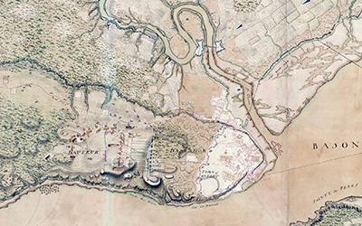
LAC NMC 21345
Detail of Québec promontory showing the positions [dotted lines] of the battle lines in relation to the topography and fortifications. Drawn from survey and signed by Patrick Mackellar, Wolfe’s chief engineer, it is used as the contemporary source reference in the Biondo map.
The maps utilized and the geo-referencing process
A contemporary manuscript battlefield map, produced by British military engineers shortly after the battle on the Plains of Abraham, 13 September 1759, had been previously digitized by Library and Archives Canada (NMC 21345).15 A commercial geographic information system (GIS) software package, ArcMap 10.1, was then used to geo-reference or ‘rectify’ this digital image. The rectification of a map involves three main aspects: the historical map, the base map, and a number of ground control points. In order to rectify a map, the user places these ground control points at similar locations on both the historical map and the base map. These control points are then paired to each other. By carefully placing enough of these control points, the user can manipulate the historical map to match up with the modern base map, in this case, a modern topographic map of Québec City.16 The rectification of the two maps reveals what is believed to be the most precise location of the British and French main battle lines as they relate to the modern streets of Québec.17
Locating suitable control points can be a considerable challenge. In the case of this specific transformation, it was a relatively easy matter to anchor the first two points along the old military fortifications, portions of which still exist today (and which can be located on the modern topographic map). However, locating additional control points outside the fortifications (near the site of the battle) was a challenge, since there are virtually no reference points on the battlefield map which can be precisely located on the modern topographic map of Québec. However, a third ground control point – critical to the process – was eventually selected midway between the Musée national des beaux-arts du Québec and Wolfe’s Monument.
Extensive modernization projects west of the city fortifications has made the 1759 battlefield topography disappear. The only remaining topographic feature with any approximation to 1759 is the elevation formerly known as Wolfe’s Hill – although altered as well for the construction of the former prison, and later, the museum itself. Wolfe’s Monument, situated in front of the main entrance of the Musée, is generally considered to be the place where James Wolfe died on 13 September 1759. It is well documented that Wolfe was carried a short distance to the west after he was shot and before he expired. Thus, a point close to these structures must suffice for the purposes of this project.

Conclusions
What exactly does the computer generated georeferenced map illustrate? It shows the initial positions of the British and French main battle lines at approximately 10:00 a.m. on the morning of 13 September 1759, with each battalion shown by either a red (British) or blue (French) rectangle.18 Omitted from the British army are the en potence (to the north) and reserve (to the west) battalions.19 Omitted from the French army are the northern and southern militia and native skirmishers. This leaves the two main battle lines directly facing each other. Also depicted, in dotted black lines, the subsequent advance of the battle lines to the distance of 36.6 meters20 between the armies, from where the British delivered their devastating volleys of fire. The geo-referenced battalion positions come directly from the 1759 surveyed engineering map authorized or endorsed by Major Patrick Mackellar, chief engineer, and an eyewitness on 13 September.
In conclusion, the map presented in this article represents the most accurate rendering to date of the British and French main battle lines as they relate to the topography of modern Québec.21 This map places the right wing of the British line (at 10:00 a.m. on 13 September 1759) on the elevation where the present Musée national des beaux-arts du Québec is located (in 1759, Wolfe’s Hill). The six battalions in the line extend to the northwest at a slight angle from that point. The line bisects Rue Grande Allée continuing northwest and ending just a few meters from Rue Fraser.
This disposition corresponds with the authors’ recent findings regarding the British regimental strengths that morning that being only a total of 1,505 other ranks directly facing the French. Almost all modern secondary accounts of the battle disposition stress the “extended north/south” nature of the British line covering the promontory. The authors’ findings of the actual manpower of the British battalions, and the required space when drawn up according to 1759 practice, does not support this ‘extended’ analysis.22
The French main battle line, before the advance westwards and the commencement of the main battle, has its southern flank anchored in Battlefield Park just south of the intersection between Rue de Bernières and Avenue Taché. From this point, it extends to the northwest, terminating its northern flank at the intersection of Avenue Turnbull and Rue de Maisonneuve. Finally, the map projects the advance of both armies to the final point of contact, between Ave Cartier and Avenue Bourlamaque, where the main firefight took place that largely determined the outcome of the battle.
Earl John Chapman and R. Paul Goodman are both officers associated with the 78th Fraser Highlanders, a ceremonial regiment raised in 1965 by Montréal’s David M. Stewart Museum to perpetuate the history of the old 78th Regiment of Foot. Earl Chapman has published extensively on the Regiment’s brief history during the Seven Year’s War, and also is a specialist, with many publications, dealing with the early history of Canada’s Black Watch, up to and including the First World War.

Fort Ligonier, Ligonier, Pennsylvania
The Death of General Wolfe, 1763, by Edward Penny [c.1763-1764]. A view of the British battle line, drawn up three deep, is pictured in the background of Penny’s near-contemporary painting.
Notes
- D. Peter Macleod, Northern Armageddon (Vancouver: NP, 2008), 301-305; Phillip Buckner and John G. Reid, (Eds.), Revisiting 1759: The Conquest of Canada in Historical Perspective (Toronto: NP, 2012).
- Journal of the Society for Army Historical Research, Vol. 92, No. 369 (2014), pp. 1-59.
- This map uses the techniques applied in Louis-Edmond Hamelin, Stéfano Biondo, and Joë Bouchard, L’Apparition du Nord selon Gérard Mercator (Québec: NP, 2013).
- Alfred Hawkins, Picture of Québec with Historical Recollections (Québec: NP, 1834), p. 357 : “… the severest fighting took place between the right of the race-stand and the Martello towers;” The Québec Guide, comprising an historical and descriptive account of the City and every place in the vicinity (Québec: NP, 1844), pp. 144-145 : “The position of the British army on the 13th of September 1759 may be easily recognized by taking this column [Wolfe’s Monument] as the position of the right wing…” The old race course was located just north of the Earl Grey Terrace.
- Sir James LeMoine, Quebec, Past and Present (Québec: NP, 1876); Picturesque Québec (Québec : NP, 1882).
- Francis Parkman, Montcalm and Wolfe, Vol II, (London: NP, 1885), p. 290: When the British line had formed, “Québec was not a mile distant, but they could not see it, for a ridge of broken ground intervened, called Buttes-à-Neveu, about six hundred paces off.” This would place the British line between Avenues des érables and de Salaberry.
- A.G. Doughty, “The Probable Site of the Battle of the Plains of Abraham,” in Proceedings and Transactions of the Royal Society of Canada, Second Series, Vol. V, Section II. Plan A follows page 378.
- “Plan des opérations terrestres du siège de Québec en 1759” (Reconstitution sur une carte moderne par G. St-Michel), Archives du Séminaire de Québec, tiroir 213, no. 19. This map, published in M. Trudel, Atlas Historique du Canada Français (Québec: NP, 1961), p. 52, has influenced some modern historians.
- A.G. Doughty and G.W. Parmelee, The Siege of Québec and the Battle of the Plains of Abraham, Vol. 2, (Québec: NP, 1901), p. 293.
- “A few remarks on ‘The Siege of Québec’ and the Battle of the Plains of Abraham, by A. Doughty, in collaboration with G.W. Parmelee; and on the Probable Site of the Battle of the Plains of Abraham, by A. Doughty,” in Proceedings and Transactions of the Royal Society of Canada, Second Series, Vol. IX, (1903), pp. 101-133.
- A.G. Doughty and N.E. Dionne, Québec under Two Flags: a brief history of the city (Québec: NP, 1903), Appendix p. XXVI, “The Site of the Battle of the Plains of Abraham.”
- “Official Programme of the 300th Anniversary of the Founding of Québec by Champlain, July 20th to July 31st, 1908 (Québec: National Battlefields Commission, 1908). Doughty’s findings on this question, although over one hundred years old, are still influencing historians. For editor Graves’ comments, see C.P. Stacey, Québec, 1759: The Siege and the Battle, Donald E. Graves (Ed.), (Toronto: NP, 2007). Footnotes, pp. 156-157.
- This map panel was published in a brochure entitled “Historic Map: National Battlefields Park” (ND, National Battlefields Commission, Plains of Abraham, currently available at the Discovery Pavilion).
- Based on pre-1999 research, the panel was revised in 2009 as part of a small exhibition at the Discovery Pavilion on the Plains of Abraham. Information received from the Commission indicates that, unfortunately, the person in charge of the project has since retired, and that they cannot guarantee the completeness of the sources used and the thoroughness with which the work has been done. This reconstruction places the British main battle line approximately 225 meters (about two and a quarter football fields) east from the location derived from this paper.
- For a detailed description and analysis of this map, see the reference in Footnote 2.
- Québec, Serié Topo, 1/20,000, No. 21L14-200-0102 (2001). The New York Public Library (NYPL) offers an on-line service to do this, which they term their “NYPL Map Warper.”
- The documentary film “Bloodlines: Who Shot Wolfe,” (Toronto: Yap Films, 2007) used a process to identify “… the precise spot where Wolfe fell.” This process involved a computer-based overlay of a 1759 battlefield map (Environs of Québec with the Operations of 1759 by Capt. S. Holland, 1760; NMC 2736) with a satellite image of modern-day Québec. This placed the left wing of the British main battle line just slightly north of Rue Fraser, extending southeasterly towards the Wolfe Monument approximately between Avenues Bourlamaque and Des érables. The Holland map is possibly a tracing from one of the larger and more detailed manuscript maps produced by British engineers shortly after the battle under the direction of Wolfe’s chief engineer, Patrick Mackellar. Not surprisingly, the two results (satellite overlay and geo-referencing) are close, perhaps within 35-40 meters (115-131 feet). Therefore, one validates the other.
- For the British line, from right (south) to left: 35th Foot, Louisbourg Grenadiers, 28th Foot, 43rd Foot, 47th Foot, 78th Foot, and 58th Foot. For the French line, from right (north) to left: Québec and Montréal Militia; La Sarre; Languedoc, Béarn, Guyenne, Royal-Rousillon, and Montréal and Three Rivers Militia.
- To the north, the 15th and the 2/60th Foot; in reserve to the west, the 48th Foot; guarding the Foulon Path, the 3/60th Foot.
- Contemporary accounts mention that the British and French main lines were only 40 yards apart when the British delivered their first volley.
- It is important to note that the process always has a margin of error, it being almost impossible to perfectly align a historical map with a modern coordinate system. Several factors must be considered, including the accuracy of the historical map – mapping methods before the age of aerial photography sometimes imprecisely represented scale, angle, distance, and direction. Furthermore, the relative position of the ground control points increases the margin of error.
- The actual length of the main British battle line (as determined from contemporary maps) is 490.15 meters (see Footnote 2). Many of the previous attempts, including the attempt by the National Battlefields Commission (Plains of Abraham), have projected the British main battle line to extend further to the north than this study indicates. Some of these attempts have extended the British main battle line as far as Chemin Ste-Foy, which is not reflected on any of the original manuscript engineering maps.


